
Get ready to have your understanding of U.S. geography turned upside down! From state sizes to natural wonders, we’ll uncover the surprising truths about America’s landscape that even the most seasoned travelers often get wrong. Prepare to be amazed as we dive into surprising details about state boundaries, unique natural formations, and unexpected climate extremes.
These insights will not only challenge your preconceptions but also deepen your appreciation of America’s diverse terrain. From Rhode Island’s lengthy coastline to Alaska’s unparalleled expanses, each fact will reveal a new layer of intrigue about the United States. Let’s embark on this journey through geographical gems and debunk some common misconceptions along the way, enriching your understanding and sparking your curiosity about the world around us.
Rhode Island: The Smallest State

Rhode Island holds the title of the smallest state in the U.S., but many people mistakenly believe it’s actually the smallest in terms of land area. The confusion arises from its official name, “Rhode Island and Providence Plantations,” which leads people to assume the entire state is called Rhode Island. In reality, Rhode Island is just one part of the state, while Providence Plantations refers to the mainland area.
Despite its small size, Rhode Island has over 400 miles of coastline due to its many bays and inlets. Additionally, it was the first of the original Thirteen Colonies to declare independence from British rule. Interestingly, Rhode Island is also home to the oldest operating tavern in the United States, the White Horse Tavern, which opened in 1673. Moreover, it hosts one of the oldest annual celebrations in the country, the Bristol Fourth of July Parade, dating back to 1785.
Alaska: The State with the Most Coastline

Alaska boasts the most coastline of any U.S. state, stretching over 6,600 miles along its jagged shores. What surprises many is that Alaska’s coastline is longer than the coastlines of all other U.S. states combined. Its vast expanse of rugged coastline is home to stunning fjords, glaciers, and diverse marine life, making it a paradise for nature lovers and adventurers.
Alaska is also home to over 3 million lakes, including the largest one, Lake Iliamna, which covers over 1,000 square miles. Additionally, it experiences some of the most extreme daylight variations, with some areas having up to 24 hours of daylight in the summer. Alaska is also rich in indigenous cultures, with 20 native languages still spoken. The state has more than 100 volcanoes and volcanic fields, and over 50 of these have been active in recent times.
Kansas: Flatter Than a Pancake?

Kansas is famously known for being flatter than a pancake, but is it really true? While a study did find that Kansas was flatter than a pancake based on mathematical calculations, the comparison is more of a fun fact than a precise measurement. Kansas does have a reputation for its expansive plains and prairies, but its topography is more varied than the pancake analogy suggests.
In fact, the state has over 28,000 square miles of forest and the Flint Hills, a region of rolling hills and tallgrass prairie. Additionally, Kansas is home to the geographical center of the contiguous United States near the town of Lebanon. Kansas is also known for its tornado activity, being part of Tornado Alley, and it hosts the annual “Wicked Windup” event celebrating storm chasing. The state is also a leading producer of wheat, earning it the nickname “The Wheat State.”
North Dakota: Geographical Center of North America

North Dakota proudly holds the title of being the geographical center of North America. Located near the town of Rugby, a stone obelisk marks the exact spot where the continent’s center lies. Surrounded by rolling plains and farmland, this unassuming location serves as a unique geographical landmark that often surprises visitors with its significance.
North Dakota also has the least-visited national park in the U.S., Theodore Roosevelt National Park, which offers stunning badlands and abundant wildlife. Moreover, the state has one of the highest rates of sunflower production in the country, contributing to its agricultural significance. North Dakota is also home to the International Peace Garden, a symbol of friendship between the U.S. and Canada, and the Enchanted Highway, featuring some of the world’s largest scrap metal sculptures.
The Great Lakes: Nature’s Inland Seas
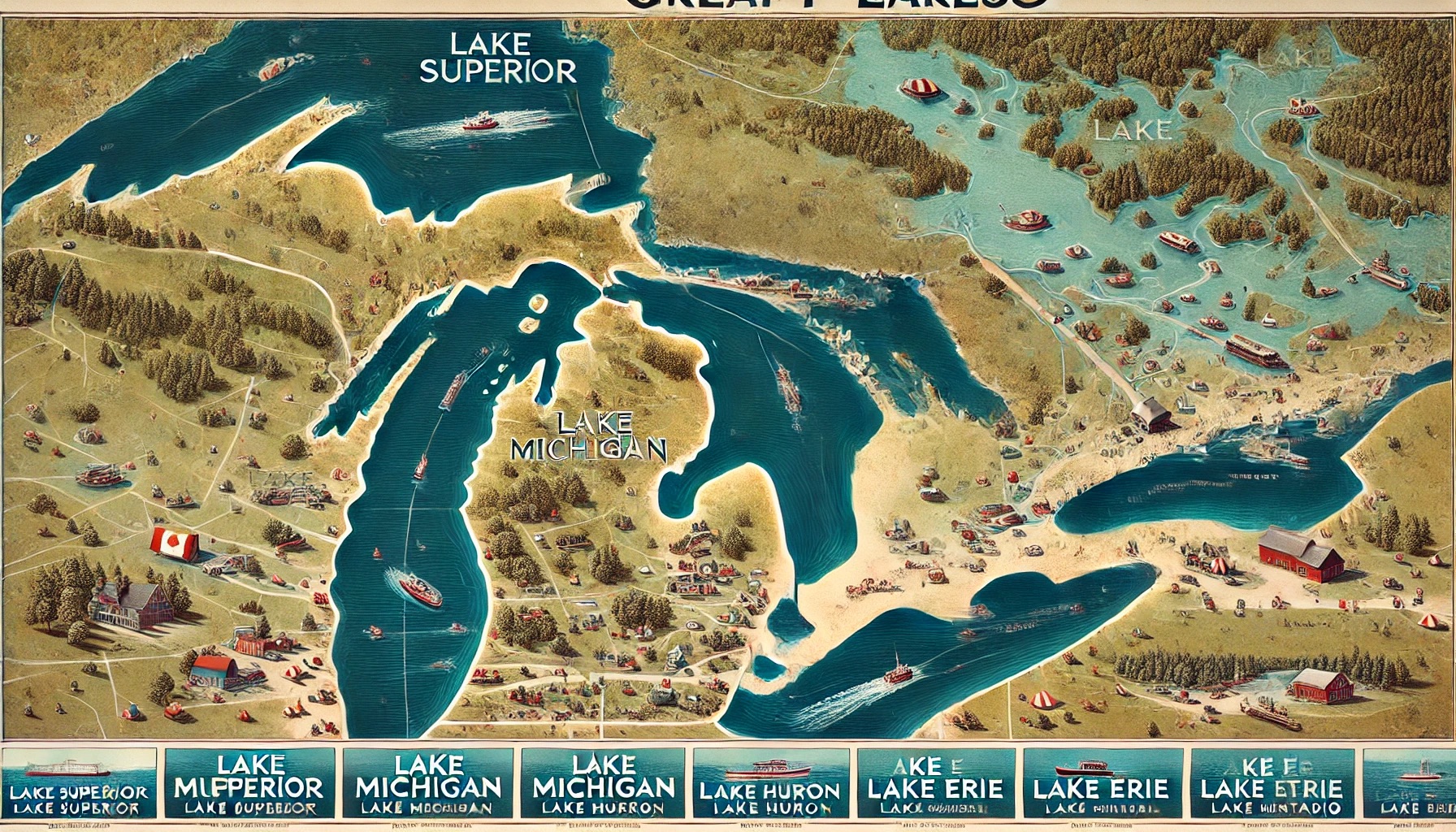
Contrary to common misconception, there are actually five Great Lakes that border the United States. Lake Superior, Lake Michigan, Lake Huron, Lake Erie, and Lake Ontario make up this impressive freshwater system, holding about 84% of North America’s surface freshwater. Each lake has its own unique characteristics and attractions, making them popular destinations for outdoor enthusiasts.
For instance, Lake Superior is the largest and deepest of the Great Lakes, while Lake Erie is the shallowest and warmest, making it popular for recreational activities. Additionally, the Great Lakes region supports one of the world’s largest economies, with significant contributions from shipping, manufacturing, and tourism. The lakes also have a rich maritime history, with over 6,000 shipwrecks estimated to lie at their bottoms, and they are home to many unique species of fish and wildlife.
Alaska: Home to the Tallest Mountain

Denali, formerly known as Mount McKinley, is the tallest mountain in the United States, standing at a majestic 20,310 feet above sea level. This iconic peak is located in Alaska’s Denali National Park and Preserve, offering a challenging climb for experienced mountaineers and breathtaking views of the Alaskan wilderness from its summit.
The mountain’s name, Denali, means “The Great One” in the native Koyukon language. Moreover, Denali is also the third highest of the Seven Summits, which are the tallest mountains on each of the seven continents. The park surrounding Denali is also home to a diverse range of wildlife, including grizzly bears, wolves, and caribou. Additionally, the area is known for its dramatic weather conditions, with temperatures that can plummet to -75°F in the winter.
Mississippi River: The Backward Flow

Due to its unique geological history, the Mississippi River is often associated with the misconception that it flows backward. While the river has changed course over millennia, leading to oxbow lakes and meanders, it does not flow in reverse.
The Mississippi River has been a vital waterway for transportation and commerce, shaping the landscape and history of the regions it passes through. The river is also the second-longest river in North America, after the Missouri River, spanning over 2,300 miles from its source in Minnesota to the Gulf of Mexico. Additionally, the river’s watershed drains all or parts of 31 U.S. states and two Canadian provinces. The river’s floodplain is one of the world’s most fertile agricultural regions, producing a significant portion of the nation’s crops.
The Great Basin: The Largest Desert

The Great Basin Desert, spanning across Nevada, Utah, and parts of California, Oregon, and Idaho, is the largest desert in the United States. Despite its vast arid landscapes and sparse vegetation, the Great Basin is not a sandy desert like the Sahara but rather a cold desert characterized by its high elevation and unique ecosystem.
This desert is home to ancient bristlecone pines, some of the oldest living trees on Earth, with some specimens over 5,000 years old. Moreover, the Great Basin also contains numerous endorheic basins, where water does not flow out to the sea but evaporates or sinks into the ground. The area is also rich in unique wildlife, such as the pronghorn antelope and the sage grouse. Additionally, the Great Basin is known for its clear night skies, making it a prime location for stargazing and astronomical observations.
Gulf of Mexico: Bordering States

A common misconception is that only a few states border the Gulf of Mexico, but in reality, a total of five states have coastlines along this expansive body of water. From Texas to Florida, these states enjoy the warm waters and sandy beaches of the Gulf, each offering its own distinct culture and natural attractions for visitors to explore.
The Gulf of Mexico is also one of the most productive bodies of water in the world, supporting a vibrant fishing industry that provides a significant portion of the U.S. seafood supply. Additionally, the Gulf is home to the world’s largest offshore oil production facilities, contributing to the region’s economic significance. The Gulf’s coastal wetlands are crucial habitats for a variety of wildlife, including migratory birds, and it plays a key role in the ecological health of the surrounding region.
Alaska: The Westernmost and Easternmost State

Alaska has the unique distinction of being the westernmost and easternmost state in the U.S. due to its location across the 180-degree meridian. While the majority of Alaska lies west of the meridian, a small portion crosses over to the eastern hemisphere, making it a state that straddles both the western and eastern extremes of the country’s geographic boundaries.
This position also means that Alaska experiences some of the earliest and latest sunrises and sunsets in the United States. Furthermore, Alaska has more active volcanoes than any other state, with over 130 potentially active volcanoes, many of which are part of the Pacific Ring of Fire. The state’s Aleutian Islands extend close to the Russian Far East, underscoring its strategic geographical significance. Additionally, Alaska’s vast wilderness areas are home to numerous national parks, including the largest, Wrangell-St. Elias National Park and Preserve.