
When Mount St. Helens erupted on May 18, 1980, it killed 57 people, erased entire forests, and transformed the region in minutes, and its aftermath continues to shape the Northwest today.
A Quiet Mountain With a Violent Past
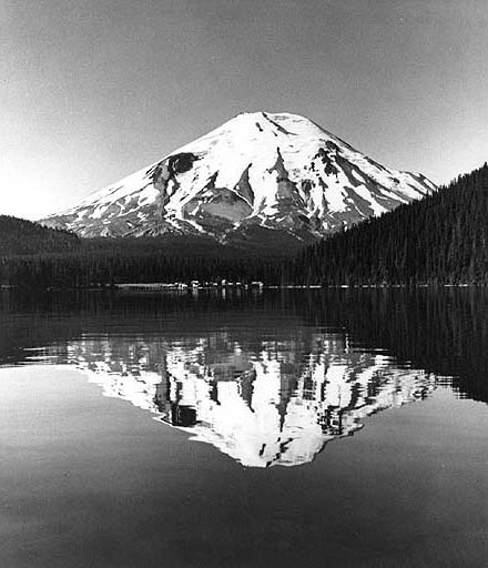
Before its catastrophic 1980 eruption, Mount St. Helens was seen as a peaceful icon of the Pacific Northwest. Snow-capped and symmetrical, it towered above dense forests, pristine lakes, and small Washington communities. But beneath that picturesque landscape, the mountain had a long, and often volatile, history.
Mount St. Helens is part of the Pacific “Ring of Fire,” a chain of volcanic activity encircling the Pacific Ocean. The volcano had erupted at least nine times before the 20th century, with its last major eruption in 1857. When it fell silent for 123 years, many assumed the danger had passed.
In the meantime, life flourished around it:
- Thousands of acres of old-growth forest spread across its base
- Douglas firs, Pacific silver firs, and mountain hemlocks grew for centuries
- Flying squirrels and other small mammals nested in the trees
- Spirit Lake attracted hikers, campers, and nature lovers with its crystal-blue waters
By 1980, nearly 8,000 people lived in Skamania County alone. Many knew the volcano was “dormant,” but few grasped how quickly dormant could become deadly.
The Early Warning Signs
The mountain awakened on March 20, 1980, with a 4.2-magnitude earthquake, the first seismic activity in over a century. Soon, thousands of microquakes shook the volcano, and new craters cracked open across its summit, spewing ash and steam thousands of feet into the air.
A report from the state of Washington, compiled in June 1980, described what scientists saw: swelling ground, rising plumes, and a rapidly forming bulge on the north slope, a sign that molten rock was pushing upward.
Authorities ordered evacuations within a 15-mile radius. Roadblocks were set up. Locals watched with fascination and anxiety as the mountain’s north flank ballooned outward at a rate of up to five feet per day.
Despite the warning signs, April and early May were deceptively calm. The bulge grew, but the volcano did not explode. With Memorial Day approaching, some officials even discussed reopening restricted areas to tourists and residents. Scientists urged caution, but only a handful predicted an imminent disaster.
None imagined how massive it would be.

The Eruption That Changed Everything
At 8:32 a.m. on May 18, 1980, Mount St. Helens violently erupted, not from the top, but from the side.
A magnitude 5.1 earthquake struck beneath the mountain, triggering an unprecedented chain reaction:
- The entire north face collapsed in the largest landslide in recorded history.
- A lateral blast, hotter than 660 degrees Fahrenheit, surged outward at 300 mph.
- Pyroclastic flows and molten debris leveled 17 miles of land in three minutes.
- An ash plume rocketed 80,000 feet into the atmosphere.
- Cities as far as Spokane, 250 miles away, were plunged into daytime darkness.
What had been a serene mountain moments earlier was now a churning gray inferno.
The destruction was staggering:
- 57 people killed
- 230 square miles of forest destroyed
- 27 bridges wiped out
- 185 miles of highways and roads damaged
- 15 miles of railways ruined
- 200+ homes obliterated
Wildlife suffered even more heavily:
- 7,000 big game animals died
- 12 million young salmon perished
- Nearly all birds and small mammals vanished from the blast zone
Spirit Lake, once a beloved recreation spot, was buried under ash, logs, and mud.
The eruption created a before-and-after divide so extreme that scientists likened the landscape to the surface of the moon.

A Landscape That Looked Like Another Planet
In the hours and days that followed, Mount St. Helens resembled a lifeless wasteland. Entire forests lay flat, trees pointing outward like matchsticks blown from a giant explosion. Ash coated everything in sight. The air hung heavy and still.
Charlie Crisafulli, a U.S. Forest Service ecologist who arrived shortly after the eruption, described the early impressions to CBS News in 2015:
“The initial impression was that nothing or few things would survive. It looked like everything had been destroyed, that all vestiges of life had been snuffed out.”
With the ecosystem seemingly erased, many believed it would take centuries for the land to recover.
They were wrong.
The Slow Return of Life
Life began reappearing almost immediately, often in unexpected ways.
- Ants and gophers emerged from underground tunnels, having been shielded from the blast.
- Prairie lupines, bright purple-blue flowers, sprouted from nutrient-poor ash fields.
- Robins flocked to the open terrain, drawn by the new food sources.
- Elk cautiously returned, feeding on emerging vegetation.
Scientists were astonished. The area became an outdoor laboratory, offering rare insight into how ecosystems recover on their own after a major geological disaster.
Even Spirit Lake, once buried, slowly came back to life. Though reshaped, wider, shallower, and warmer, the lake now supports different species, including trout and a thriving community of insects. Dead logs floating on its surface have become a “floating ecosystem” of their own.
According to the U.S. Department of Agriculture, the eruption also created 150 new lakes and ponds, contributing to a complex and evolving ecosystem around the mountain.
Some species, like flying squirrels, never returned. But overall, nature’s resilience exceeded expectations.
A Protected Monument for the Future
In the eruption’s aftermath, U.S. Congress designated 110,000 acres around Mount St. Helens as the National Volcanic Monument, ensuring that the landscape would be protected from logging, development, or interference.
The goal: let nature heal itself, and let scientists observe how it happens.
Today, the area stands as a unique blend of devastation and rebirth. Visitors can witness toppled forests preserved in place, newly formed lakes, and regrown meadows. The exposed crater remains a stark reminder of the mountain’s power.
And, as geologists often note, Mount St. Helens is still an active volcano. Though decades have passed since 1980, smaller eruptions and dome-building events have occurred since. Most experts agree: the mountain will erupt again, it’s just a matter of when.
A Before-and-After Story Still Unfolding
The 1980 eruption did not simply change Mount St. Helens. It reshaped the land, transformed scientific understanding, and created a landscape that continues to evolve.
Before the eruption, the mountain symbolized natural beauty. Afterward, it became a living classroom, a stark illustration of destruction and renewal existing side by side.
Forty years later, researchers still track how forests regrow, how species adapt, and how the mountain continues to rebuild itself. Their work ensures that the story of Mount St. Helens, and the lessons it carries, will not be forgotten.
Because in the aftermath of one of the deadliest volcanic eruptions in American history, the mountain proved something extraordinary:
Even in the face of total devastation, life finds a way back.
Featured Image from: UW Digital Collections, No restrictions, via Wikimedia Commons